Day 1
The year had flown by and it was time for The Big Hike. A year in the planning all leading up to this moment. Many hikes at Essex / Gloucester Reservoir, many work-outs at Boston North on the stair-master and later the weight machines, all in suspense of the 5th Annual Bike Hike. A full year to think about new gear and better ways to be a more efficient backpacker. The plan was to hike for five days, four nights, and carry enough food and clothing for that. This would be my third attempt at this stretch of trail; the infamous Mahoosuc Ridge and perhaps the toughest section of the entire A.T.

This year involved no route planning. The route I would take was already determined well in advance. The only question was where to start. There was no doubt it would be Success Pond Rd. in Berlin, NH, but where? A matter of miles on that long, dirt, valley road could literally mean the difference of a day. One thing was for sure, I had to climb back up one of my favorite mountains; Goose Eye Mountain.


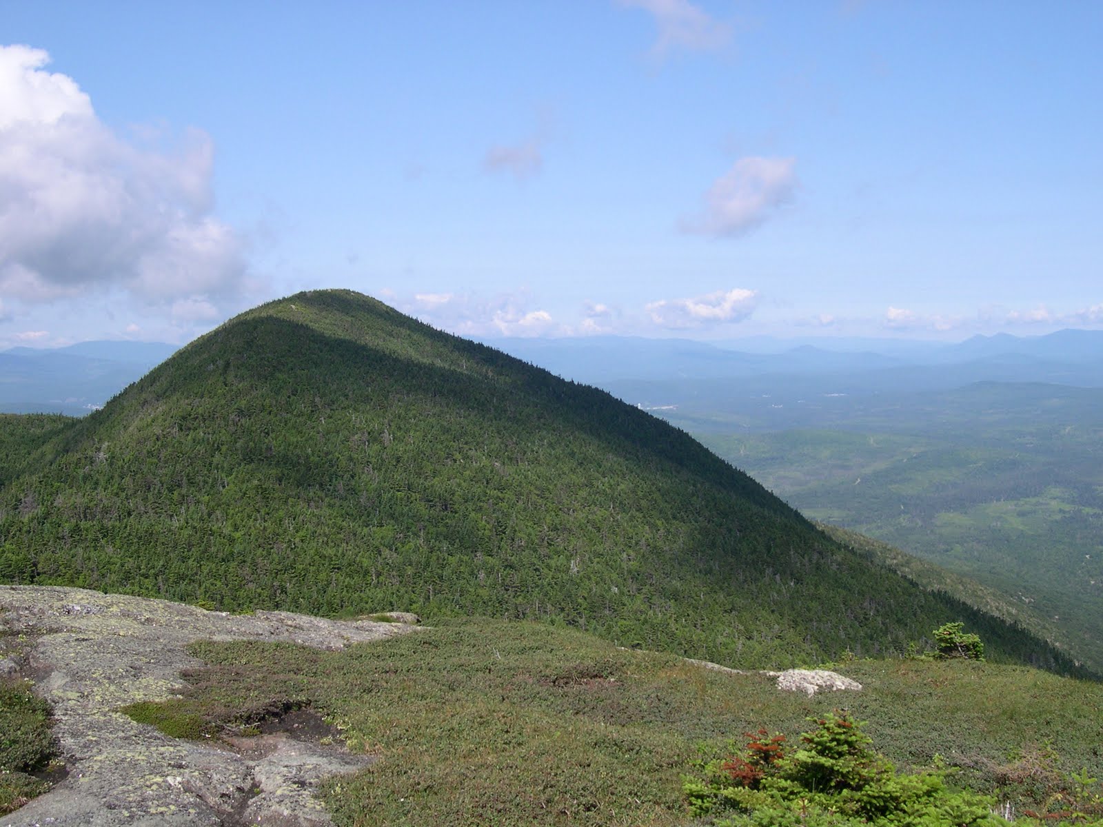
The above pic is of Goose Eye Mountain's east peak. Goose Eye Mountain is the first mountain encountered in the beautiful western mountains of Maine. For the last three years it has been the first mountain obtained on The Bike Hike. It is a two headed beast with an east and a north peak. Once off of the steep descent from north peak you enter an attractive 'tableland', a sort of alpine garden, although it's east peak only reaches 3,794ft.

It is a nostalgic mountain for me. It has marked the beginning of the Bike Hike for the past couple of years. It begins a stretch of tough, steep and rugged terrain anywhere in the Appalachians. This year I was ready for it. I had trained for this trip and I was going to make my goal of rt.17 in Oquossoc, ME that I had come short off each of the past two years. The first attempt I had only made it to Grafton Notch. The year after I had made it a bit further to East B. Hill Rd. This year I was not to be denied.

The mountains of southwest Maine are not intimidating in size and looking at them on a map one might not be daunted by hiking any of them. But based on prior experince and accounts from several through-hikers I encountered, this stretch features some of the steepest trails in the northeast. The above pic is only a small indication of the various notches and steep, little mountains that the AT goes over. In fact, the stretch I was to hike is some of the most geologiocally interesting terrain in New England. It's notches are famous. Grafton Notch on rt.26 and the Mahoosuc Notch are two of the toughest routes you could ever hike. It's also thick with wildlife. Black bears are common and moose are common, both of which I was anxious to see. I have seen several moose on the trail but never a black bear.
The trail I took up Goose Eye Mountain was the Goose Eye Trail. It leaves Success Pond Rd. from Berlin, NH about 9 miles in. It's a good dirt road that has several trails that run up into the Mahoosuc range. After reaching Full Goose Shelter where I took a long break and headed towards the dreaded Mahoosuc Notch. A mile long hike over, under, around, and through huge bolders, it's said to be the 'toughest mile' on the AT. And tough it is as it takes approximately 2 hours to traverse. It is incredible hiking. It is an extremely narrow notch between Mahoosuc Mountain (or the Mahoosuc 'Arm' really) and Fulling Mill Mountain with the steep cliffs of each mountain visible the whole way through. At times it seems that more giant boulders could come tumbling down at any time. Unfortunetly I don't have any pics. At about 1:00pm sitting at Full Goose Shelter it began to rain steadily.

Now the notch is tough enough, but in the rain it was much tougher than the previous two times I'd been though. All the boulders were very slippery causing it to take longer than usual. The rain didn't let up and once I made it through I stopped for a nice long break and struggled to smoke a soggy cigarette. My goal for the day was to make it to Speck Pond Shelter 12 miles from my trailhead. The longest day of my hike was necessary due to the lay out of shelters available. The notch is tough and long and takes a lot of energy from you but the toughest thing about it is the fact you have to climb the steep Mahusooc Arm immediately after you finish the notch. An absolute killer.
After the grueling climb up the arm you are rewarded with a nice easy descent to Speck Pond, the highest tarn in Maine. Speck Pond Shelter is a gorgeous camp site sitting right on the pond and is located on the long saddle between the Mahusooc Arm and Old Speck Mountain. It is such a desolate and quiet pond, one of my favorite places in the world.

Soaked, exhausted and sore I rolled into the campsite at about 5:00pm with the rain still steadily coming down. There was a father and his two boys along with the caretaker hanging out in the lean-to. I put some nice, dry clothes on from within my new dry sack and began to relax and felt as if I would stay in the lean-to for the night. The rain didn't look like it would let up. But it did eventually. I chatted for a bit, had a sit at the pond and set up my camp for the night quite satisfied at the day's progress. I felt good and strong having hiked 12 miles over and through some rough terrain. I felt that I would not fail this time.
Day 2
No more rain. For the rest of the hike I had perfect weather and no excuses. The second day would be even tougher than the first as I would have to climp up Old Speck Mountain and then down into Grafton Notch, only to have a nice late afternoon climb up Baldpate Mountain.

The morning started with a nice, steep but rewarding climb up the bare slopes of Old Speck Mountain, another one of my favorite mountains. The fourth highest mountain in Maine at 4180ft, it was the only 4,000fter I was to climb on the trip. There is a spur trail about .5 miles up to the unspectacular summit. It does have a cool fire tower though.


After taking a nice break at the summit area of Speck I started the long 3.5 mile steep descent into Grafton Notch. Located on rt.26 just west of Bethel, ME, it is a spectacular mountain pass in between Old Speck Mountain and Bladpate Mt. The descent is long and grueling. A hiker passing by informed me that they may have re-routed the trail going down and I do remember it being slightly easier than years prior. It's still one of fiercest downhill climbs I've ever hiked. It's length and steep sections take more energy that you would think leaving you virtually drained to climb Baldpate. I had planned a long late lunch break in the notch. It has nice picnic benches.

This pic above is the only one I snapped on my iPhone. I am making the hike sound really lovely and beautiful up to this point. But by the time this pic was taken at the summit of Baldpate I was almost dead. The climb up to Baldpate is in many ways the start of the ridiculous steepness that characterizes this stretch of trail. It is an amazing mountain. Consisting of two peaks very close to each other, west and east, the climp up to each peak is exposed. The granite slabs are like huge stairs and they are at an angle making it a rather awkward climb.
The descent to Frye Notch lean-to was no easier. After climbing up and over the two spectacular peaks of Baldpate Mt. I was drained. A sharp, steep descent of just under two miles lay ahead before Frye Notch. This is where I had given up the year before. Feeling the strain of the heat wave and dealing with dehydration, this was the spot where I was unable to pull it together and push on. I remember forcing down a snickers bar and lots of water in hopes of recuperating, only to be lured by the hiker hostel adds posted up on the lean-to walls. I was temporarily relieved by some marijuana. I had almost considered calling one of these hostels rather than deal with the humiliation of calling my mother for the second year in a row. But this year the work outs at the gym had paid off and physically, I felt fine. It was a great nights camp at Frye Notch. It has a good size lean to plenty of nice tent spots up in a wide open area above the lean-to Of note here where some late thru-hikers that came in. I spent some time observing them and trying to socialize. I find thru-hikers are less likely to socialize with people who are not out to hike the entire A.T. For this reason I had grown bitter with them through the years. Someday I would like to do a thru-hike and I wanted to talk with them and ask them about their journey.
Day 3

I had gotten over the hump of my journey and I felt strong. Already I was ahead of my progress of the last two years.
The next day featured the only hint of a break from the steep terrain I was in the middle of. In the morning a sharp but steep climb up to Surplus Mt. was the toughest part of the day. A lengthy moderate descent followed into Dunn Notch, the third of these great notches.

As I descended on the notch where I had quit the year before, many feelings of excitment and anxiousness filled me. I stopped at the top of the beautiful cascades and admired the beauty. I tried out a new method of eating this morning. I only had an energy bar before I set out for the morning. I decided I would try stopping mid-morning to cook a substantial meal. I cooked oatmeal with raisons and was satisfied by this. I snapped this pic above which does little to describe the beauty of this notch. In the bottom of the frame is a cascade that is not visible. What is amazing is the steep drop into the notch just below the frame. To look through a narrow pass like this into the valley below is a truly amazing view.
Content and re-energized I began the ascent up to East B Hill Rd.
It is here that I began to notice the strain of my pack. I find it is on the moderate descents and acsents that you begin to notice the strain of the weight you are carring. You are rielieved of the strain of the steep terrain and begin to focus on the strain of your pack. By this time I begun to develope some very painful rashes on my hips that woul later become a problem.
Surplus Pond is a beautiful spot. It is a quiet, desolate spot. There is an old dirt road there that leads to a property just off of the pond. Just like the year before I decided to fill my water bottles and use this spot as a relaxing break point. A two mile ascent followed up Wyman Mt, and I wanted to have peak strength. From East B. Hill Rd. it pretty much a gradual 6 mile hike up to the summit of Wyman Mt. It is here that you first get start to get a sense of the remoteness and solitude of this section of trail. You start to see fewer people and the likelihood of seeing wildlife improves.
It was here two years before that I remember getting caught in a feirce rainstrom and getting throughly drenched before reaching Hall Mt. lean-to on the northeast shoulder of Wyman Mt. I had slept here 2 years before and was familiar with the accomadations.
I had made it to a lean-to for the third night in a row and felt good. If I got an early start the next and made good time I had some interesting options.
Day 4

Aside of the fact that I came in contact with human fecses twice during my stay at the lean-to, the weather was still beautiful and I felt strong and ready to go the next day. I had lasted 3 nights and 4 days in some of the fiercest terrain in the northeast. Looking back to the mountains I had conqured as I began my hike in the morning, I was proud of myself and knew that when I made Old Blue Mt. I was most likely going to become emotional.
The day that followed was one of the most memorable days of hiking I've ever had. It is the whole reason why I backpack and dream of longer distance backpacking. The trail became more and more remote and the ascents and descents became steeper. It remains my favorite stretch of trail in between East B. Hill Rd. and rt.17.
Sawyer Notch (no link) is perhaps the narrowest, most remote notch in Maine. The descent into the notch was incredibly steep. Along the way I saw a moose. I had gotten a very early start and was fortunate to then see the hind side of a black bear as I crossed over Sawyer brook at the bottom of the notch. The ascent that followed up to Moody Mt. is the steepest one mile stretch I've ever hiked. Erosion has damaged the trail in recent years and the detour that I encounterd was the same detour that I followed two years earlier. I can't stress enough how steep this ascent to Moody Mt. is. It is a constant scramble up dirt ledges. Needless to say I was very tired by the time I hit the 'summit'. Put to the test by this obstacle I was still in good shape for the steep descent into Black Brooke Notch at the base of Old Blue Mt.
Approaching South Arm Rd. I became overwhelmed with excitement. This was the starting point of the First Annual Big Hike. I remember my mother snapping a photo of me as I set off into the thick, dark forest and only imagining her concern. It was here that I started the annual tradition. It was here that I began my journey.
I remember taking a break on the road and being meet with the care taker at the Andover, ME hostel. I made conversation with him and told him how all the hikers raved about his hostel. He gave me lemonade. It was the single greatest refreshment I've ever had. After a good long break I saw him off as he shuttled off a weary hiker and I began the last great ascent of my hike. It was on to the summit of Old Blue Mt.

At 3,600ft, it was the third highest peak reached. When I summited this mountain back in 2008, I thought it was the most beautiful peak I ever hiked. It features a panoramic view of the surrounding western Maine mountains.

The summit of Old Blue Mt. is one of my favorite summits. The landscape is breathtaking. I was constantly bsing rewarded for my steep climbs and over exgertuion. The climb up the mountain is very steep and features a nice 'old growth', 'boreal' forest. This means that most of the trees have died and are rotting in 'boreal' moss on the floor of the forest. The old trees dying are giving way to small but distinct trees waiting to take the forest over and thus change the habitat.
As I took my map out and studied it, I saw an out. I saw a possible route to rt.17 and relief from hiking, a chance to be done that very day. My original plan was for one more night of camping at the Bemis Mt lean-to about 6 miles from Old Blue. What I saw and knew was there was the Bemis Stream trail. It was about 3 miles away just above the small col from Elephant Mt. and Bemis Mt's tallest peak. It was 6 miles to the road via the Bemis stream trail but all downhill and very moderate. I decided that I would take this route and arrive at the road a day earlier. I felt no shame in this as I had reached my goal and out lasted my progress from the two years prior. I set out from the Summit of Old Blue in good spirits thining of burgers and beer from Sarge's in downtown Rangeley ME.

I was disapointed in myself slightly. I would not be able to view one of the finest views in the western mountains: the descent off of Bemis Mt. It offers beautiful views of Mooselikmeguntic Lake in Oquosic ME and the Rangeley Lakes Region, my destination. But I was tired and done. My sleeping pad had been leaking the whole trip. I had to blow it back up with air five or six times a night. I was tired of water. I had a nasty rash on my hips from the sweat produced by m pack rubbing up against them. It would be 9 miles back down to the road downhill. I called my mother, swore when she didn't answer and finally got through to her. I told her 6pm at the trail head of th Bemis Stream trail on rt.17.
I coralled my nostalgia, suited up and continued over familiar terrain. A nice descent into the col before Elephant mt. where I snapped this pick 5 years earlier as a nieve hiker wondering why the trail did not traverse the summit.

The trail does not traverse the summit of Elepaphant mt although it is a 3,000ft. The col between Bemis and elephant mt is wet and boggy. Eventually it gives way to the most beautiful low altitude ridge I know of. Wide open and at moderate grades, it is a pleasure to hike.

I made it to the junction of Bemis Stream trail early afternoon, took a break and become very excited at the prospect of being finished. I scraffed down a quick snack and some water and headed dwon the seemingly easy 6 mile, gradual descent to rt.17. It was not easy. A interesting thing happens when one comes to the end of a four day trip and can smell the finish line. It is my theory that the body reactes to the mind;s awareness of being almost done. Your muscles start to relax and you start to fatique easier compared to if there was two more days to go. The body and mind would relaize that and thus produce the nesceassry endurance required to make i the rest of the way. This is what I went through as I hiked down this trail. The trail became very boggy and wet and I remeber having to completely submerge my feet in water to cross a few swampy areas. There was intense logging being donw on the sides of the trail, so much I wondered how the trail was even still there and how I could still follow it. Increasly fatiqued I began to really labor in this stretch. The grade was very moderate but this contributed to the burden of my pack which was now rubbing and infecting my hips and shoulders. I fibally came to an unmarked dirt road just near a bridge and took what was to be my last break. It started to rain very hard. I had had amnazing weather virtually the whole time and it seemed fitting to be getting thourougly drenched at this stage. I became angry and frustrated that the six miles was seemongly taking much longer than anticipated. I even swore the taril had been re-routed because of the logging and extendee and extra mile (which turned out to be true.) At last I reached the road having endured the brutal last mile uphill climb. It was downpouring and I began to get cold. The kind of cold that up in Maine is very dangerous even in summer as hypothermia is a far more ommon occurance and amnybody thinks. My mother was late due to some road work and didn't bring me a beer. But I was done. I was very proud of myself even for skipoing out o the last cambing night. I made reached my destination for the first time o this stretch of trial. What was I going to do next year?